


Marine : Hamburg West Germany - GPS maps Navigator
!! TRY before BUY !!!
Try now the new FlyToMap web viewer to see all available maps worldwide !!! Visit viewer.flytomap.com
“New iPhone Marine Map Navigator”
“Customers Choice Best Marine Apps Provider for iPhone, iTouch & iPad devices”
“FlytoMap has a reputation for providing innovative Marine Maps and outstanding technological support for our customers at all times.”
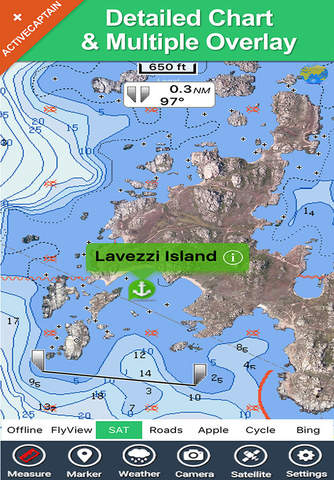
These are High quality maps with detailed water navigation information and important features compressed to assure the larger coverage.
Hamburg Marine Map Navigator can be used by mariners at all levels, Fishermen, Leisure Sailors, Ocean Cruisers……and more…..!
Use the Map:
•GPS functionality
• Mark unlimited Waypoints, Favorites
•Record tracks and email to anyone
•Various speed, memory and usability optimizations
•Map Overlay
•Navigation Compass
•Advanced Search Function
•Send by e-mail your Favorites and Photos
Hamburg Marine Map contains embedded Electronic Nautical charts compressed to a large coverage. Now you can download the Map and transform your device or devices in a Chart Plotter with best Marine Cartography which includes Depth Contours, Soundings, Fishing areas, Anchorage Areas, Buoys, Beacons, Lights, Obstructions, Restricted Areas, Marinas, Ports etc, with requisite values.
Note:
"Continued use of GPS running in the background can dramatically decrease battery life."
Note: Turn OFF GPS when not in use.